
Last Updated on: 6th November 2025, 03:42 pm
The iconic view of the northern Drakensberg mountains is the Amphitheatre – an impressive, curved wall of basalt cliffs.
Tugela Falls, the world’s tallest waterfall, drops over the Amphitheatre escarpment into the gorge below in 5 tiers.
Tugela Falls may be very high, but it is low volume as it has a small drainage area. There is no guarantee of seeing the Falls in flow – there are times when the stream (or even the Falls) is frozen and there are times when it is dry.
The only way to see Tugela Falls from relatively close up, is to hike to viewpoints above or below the Falls.

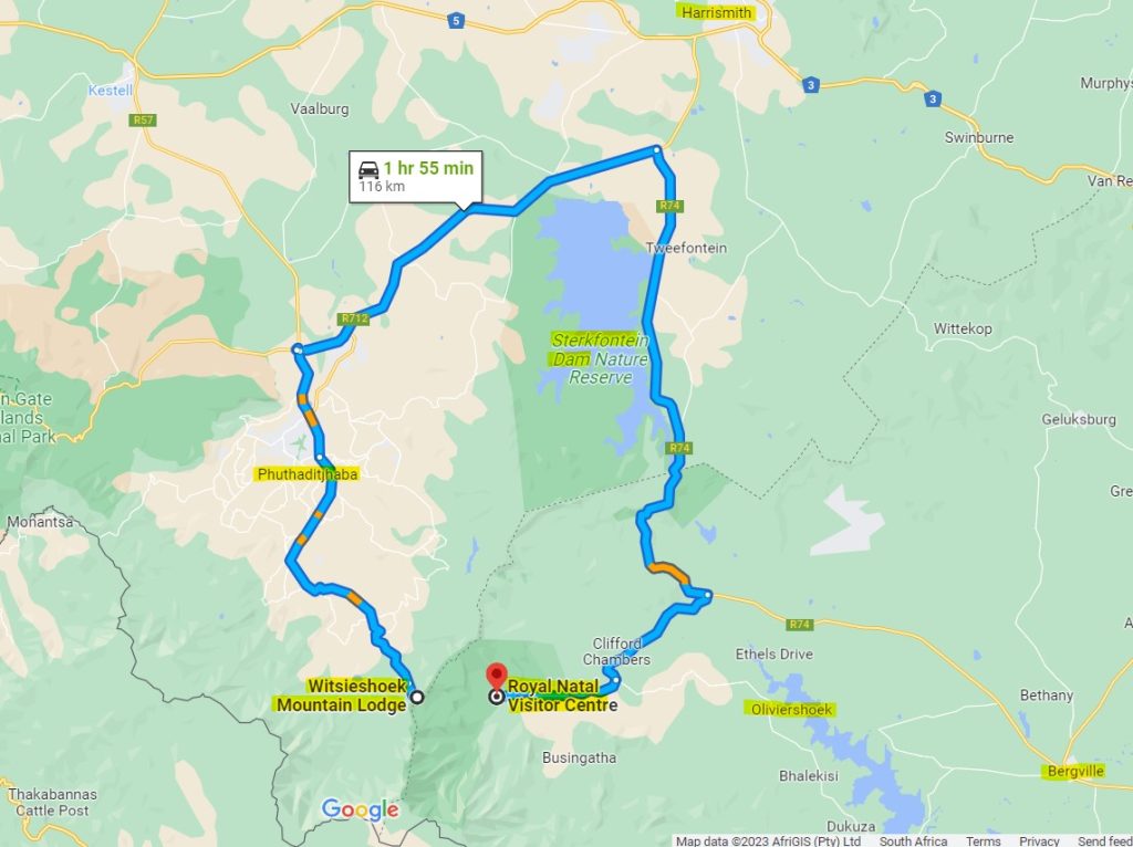
Royal Natal National Park and Witsieshoek Mountain Lodge (with nearby Sentinel Car Park) provide access to the best-known hikes in the area. As the crow flies, Thendele Camp (Royal Natal National Park) (1600 m) and Witsieshoek Mountain Lodge (2200 m) are a few kilometres apart. The only direct route between them is however via hiking trails; it is +- 120 km by road between the two.
There are several other accommodation options in the northern Drakensberg. In general however, the tourist infrastructure in the area is not as developed as that of the Champagne Valley / Cathkin Park in the central Drakensberg.
Is Tugela Falls the highest waterfall in the world?
There is contradictory information about the heights of the world’s waterfalls.
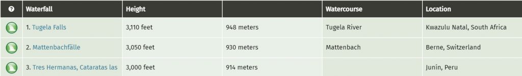
Until about 2020, Angel Falls (Kerepakupai Merú) in Venezuela was regarded as the tallest waterfall in the world (by overall height) with Tugela Falls the second tallest waterfall (by overall height).
The accuracy of the Angel Falls measurement (from 1949) has however been called into question. The experts from the site https://www.worldwaterfalldatabase.com/, now regard Tugela Falls to be the tallest waterfall in the world (by overall height) with an estimated height of 948 m (3,110 ft). (Worldwaterfalldatabase.com does not recognize the even higher 983 m measurement of the 2016 Czech team saying that it cannot be proven to be accurate.) [1]
Royal Natal National Park

Royal Natal National Park is part of the uKhahlamba-Drakensberg Park which in turn forms part of the transnational Maloti-Drakensberg Park World Heritage Site.
Despite its name, Royal Natal National Park is managed by KZN Ezemvelo Wildlife http://www.kznwildlife.com/ and not SANParks. Royal Natal National Park offers camping at Mahai Campsite for campers and caravanners and cottages at Thendele Upper and Lower Camps. These camps are very popular. (Rugged Glen Campsite is currently closed.)
Royal Natal National Park Hikes
The Royal Natal National Park conservation / entrance fee for day hikers (2025/2026):
For RSA citizens / residents and SADC nationals: R80 per adult, R40 per child. [2]
The Visitor’s Centre may have maps available.
Tugela Gorge Hike (15 km)
(Still to be personally reviewed)
This is the hike where you can see partial views of Tugela Falls from below. For this reason, it is sometimes mistakenly referred to as the Tugela Falls Hike.
There is parking at the base of the Thendele hill and the Tugela Gorge hiking trail starts here. It can be done as a half-day hike, but to me it makes sense to spend as much time as possible exploring this incredibly beautiful environment.
The trail follows the river upstream and after a few kilometres, reaches the Gorge itself.
At the start of the tunnel section, there is a chain ladder on the cliff on the right-hand side. This allows you to walk around the tunnel. Another option is to clamber through the awesome sandstone tunnel (water levels permitting). The chain ladder is currently officially closed but can be climbed at your own risk (according to a lady I spoke to at RNNP (Oct 2022)). I suggest you check with RNNP when you are there.
I have read that there is a good view of the Falls if you head up to the cave which is to the left of the tunnel.
At a point after the tunnel, you will continue further by boulder-hopping up the Tugela. The route then becomes very difficult with huge rocks to be negotiated. You don’t want to be trapped by flood waters, so it is wise to keep an eye on the weather.
You return via the same route. The trail as described above is about 15 km long with a cumulative elevation gain of +- 765 m.
If you would like to view an interactive map of this trail, please go to: Map of the Tugela Gorge Trail in the Drakensberg (The AllTrails app is needed if viewing the map on your phone).
Other hikes
Still to be reviewed.
Witsieshoek Mountain Lodge and Sentinel Car Park
Long-established Witsieshoek Mountain Lodge is now owned by the local Batlokoa community. It has great views in a remote setting and is the most convenient place to stay for an early start to the Tugela Falls via Sentinel Peak / Amphitheatre via Chain Ladders hike.
To get to Witsieshoek Mountain Lodge and Sentinel Car Park, you drive through Phuthaditjhaba (the capital of the former “black homeland” QwaQwa). A few kilometres before the road splits, there is a toll gate which allows further access to the road to Witsieshoek Lodge and Sentinel Car Park. There can be problems with signal to process card payments, so cash backup is a good idea.
Witsieshoek Mountain Lodge offers a range of accommodation from high-end units to a backpackers’ cabin.

It is about 8 km from Witsieshoek Lodge to Sentinel Car Park. Much of the road is in very poor condition and a 4WD is recommended. Alternatively, you can book the Lodge shuttle service (even if you are not staying at the Lodge). It is well worth stopping along this road to admire the great views.
For information re toll fees, Sentinel Car Park hiking fee, guides and shuttle fees, please see: https://www.witsieshoek.co.za/optional-activity-rates
Speak to the Lodge about visiting the vulture restaurant to see bearded vultures (lammergeiers).
Hikes from Witsieshoek Mountain Lodge and Sentinel Car Park
Tugela Falls Hike via Sentinel Peak / Drakensberg Amphitheatre Hike via Chain Ladders
The Tugela Falls Hike / Amphitheatre Hike starts at the Sentinel Car Park (2550 m). The trail heads upwards and after about 2.3 km and an elevation gain of +- 260 m, the path levels off and continues around Sentinel Peak.

After you pass the saddle between Sentinel Peak (3165 m) and Beacon Buttress (3124 m), there is a gully (Beacon Buttress Gully) which is the original route up the escarpment. The Gully is steep and requires some scrambling in places. It tops out at about 3090 m. This is the route to take if you think the chain ladders will be too nerve-wracking for you. According to Reg Pearse, in his classic book, Barrier of Spears, the chain ladders were installed as: “This Gully was often rendered impassable in winter through being choked with snow and ice.”
Please note that I have not hiked the Beacon Buttress Gully route.
Some people combine this route (up or down) with the chain ladders to allow for a more circular hiking route with some variety. The Gully has loose rock so be aware of hikers below you.
Otherwise, continue along the contour path to the chain ladders. There are two sets of chain ladders (next to one another) and two sections in each set.

How high are the Drakensberg Amphitheatre Hike chain ladders?
There is wildly varying and incorrect information out there regarding the height / length of the chain ladders. Tony Marshall led the team that repaired the chain ladders in 2021 and I reached out to him via the forum of vertical-endeavour.com. He kindly provided the following detailed and definitive response:
(Note: the left and right ladder referencing is when viewed from below.) The left and right ladders are not exactly the same length and are from different eras. For the bottom ladders the older one is on the left, and the newer one on the right, and for the top ladders the older one is on the right and the newer one on the left. The older ladders are made from 10 mm long link chain, with rung spacing of 320 mm, and the newer ladders are made from 13 mm standard chain with a rung spacing of 290 mm. The older and newer ladders also have different types of rungs, and different designs to space the rungs and chains away from the rock face. All four ladders also have excess chain at the bottom of the ladder, which is not climbed, and rests on horizontal rock, and I have not included this excess chain length in the measured lengths of the ladder heights.
The ladder individual lengths are:
Bottom left: 23 m
Bottom right: 24 m
Top left: 14 m
Top right: 14.4 m
This route tops out at 3000 m. Once on the plateau, you follow the path that leads south-eastwards to the top of Tugela Falls (2960 m). You will need to walk along the escarpment to find good viewpoints to photograph the Falls. The views are spectacular!

There are sometimes Basotho shepherds on the plateau who approach hikers for money and food. In order not to encourage this practice but still treat the people in a respectful way, it is recommended never to give money but rather give token food items.
If you still have lots of time, you may wish to visit Mont-aux-Sources (3282 m), the famous watershed where tributaries of some of South Africa’s main river systems have their beginning.
Keep an eye on weather conditions as reduced visibility can lead to disorientation.
According to AllTrails, the route up and down the chain ladders is about 12.4 km long with a cumulative elevation gain of +- 663 m. Our measurements indicate that +- 520 m is more accurate (465 m (outbound) + (45 m +10 m) (return)). Please note that there are no steep ascents or descents on the contour path between the Sentinel and Chain Ladders as indicated on some maps of the trail.
The AllTrails map shows two other paths west of the Sentinel. These can be used to avoid a portion of the contour path if it is unsafe in wet conditions. The longer option starts before the metal ladder.
If you would like to view an interactive map of this trail, please go to: Map of the Tugela Falls Amphitheatre Hike via the Chain Ladders (The AllTrails app is needed if viewing the map on your phone).
The route up Beacon Buttress Gully and down the chain ladders is about 11.7 km long with a cumulative elevation gain of +- 780 m.
If you would like to view an interactive map of this trail, please go to: Map of Tugela Falls Amphitheatre Hike via Beacon Buttress Gully (The AllTrails app is needed if viewing the map on your phone).
Other hikes
Still to be reviewed.
Oliviershoek Pass route
Oliviershoek Pass
Oliviershoek Pass is on the R74 between Harrismith and Bergville. It is the scenic alternative route to Van Reenen’s Pass.
Sterkfontein Dam

Sterkfontein Dam is at the top of Oliviershoek Pass and was built to divert water from the upper reaches of the Tugela River in KwaZulu-Natal to the Vaal Dam. It is a particularly effective dam because it is deep and has small surface area thus reducing evaporation. It is generally very windy here and the dam is popular for wind-based water sports. Flamingos sometimes visit.
The small Driekloof Dam adjoins Sterkfontein Dam and is the upper storage dam for the Drakensberg Pumped Storage Scheme.
Sterkfontein Dam Nature Reserve is a small-scale nature reserve.
Voortrekker Historical Sites
Kaalvoetvrou Monument and Retief’s Pass
(Still to be reviewed)
This monument is located about 12 km on a dirt road off the R74.
The Kaalvoetvrou (Barefoot Woman) Monument honours spirited Voortrekker Susanna Smit, who declared that she would rather walk barefoot back over the Drakensberg than live under British rule in Natal. (She did not in fact do this.)
Nearby is Retief’s Pass where Voortrekker-leader Piet Retief’s party descended the Drakensberg mid-November 1837.
Kerkenberg Retiefklip
(Still to be reviewed)
The Voortrekkers camped in the area that they named Kerkenberg. At this time, Piet Retief explored Natal and visited Zulu king Dingane. On his birthday, while he was away, his daughter Debora wrote her father’s name and date on an overhanging rock in green paint, and this can still be seen today.
References:
- https://www.worldwaterfalldatabase.com/waterfall/Tugela-Falls-2 retrieved 202210
- http://www.kznwildlife.com/Tariffs.html
You may also like:
Monks Cowl Reserve in the Drakensberg
Encountering baboons in the wild