Last Updated on: 11th January 2026, 04:03 pm
There are several hiking venues and hiking trails in and around Gauteng, but many hikers prefer a trail that provides some distance and elevation change (gain and loss).
In general, I will be covering day hiking trails that are 10 km or more in length and have more than 400 m (total) elevation gain.
Bokmakierie Trail – Suikerbosrand Nature Reserve
Suikerbosrand Nature Reserve is south of Johannesburg on the way to Heidelberg.
This hike is an 11.9 km circular route and the cumulative elevation gain is +- 436 m. At around the 6.8 km mark, there is a shorter route of 10 km that splits off to the right.
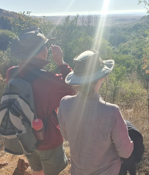
The trail has pretty sections where you feel immersed in nature and other sections that provide views of greater-Johannesburg in the distance.
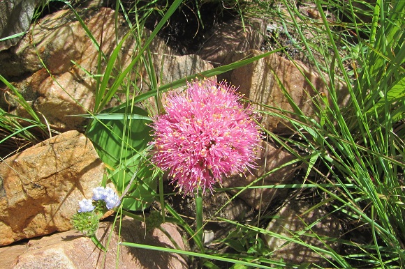
As the trail is in a nature reserve, you may be lucky and see some wildlife.
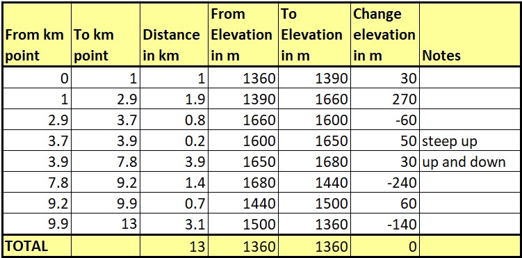
Please see below a breakdown of the trail:

If you would like to view an interactive map of this trail, please go to: Map of Bokmakierie Trail in Suikerbosrand Nature Reserve. (The AllTrails app is needed if viewing the map on your phone).
There are toilets in the office building and a decent long drop at about the 6.8 km mark on the trail.
For more information about hiking at Suikerbosrand Nature Reserve, please see: https://www.friendsofsuikerbosrand.co.za/
Krokodilberg Trail – Hennops Hiking Trails

Hennops Hiking Trails is west of Pretoria on the R511.
This hike is a 10 km circular route and the cumulative elevation gain is 389 m.
There are historical points of interest along the trail which are nicely explained in the brochure provided as part of the entrance fee. Some added features are a suspension bridge river crossing as well as a fun cable car crossing at the end.
The setting is very pretty but Pelindaba does spoil the view from sections of the trail.
Please see below a breakdown of the trail:

If you would like to view an interactive map of this trail, please go to:
Map of Krokodilberg Trail at Hennops Hiking Trails. (The AllTrails app is needed if viewing the map on your phone).
For more information about hiking at Hennops Hiking Trails, please see: https://www.hennopstrails.co.za/hiking-trail/
Klipriviersberg Trails – Klipriviersberg Nature Reserve

Klipriviersberg Nature Reserve is situated in the southern suburbs of Johannesburg. Yes, there is a sewerage pipe and power lines and there are busy roads visible from some sections, but there are also lovely large areas that are unspoiled and natural. If you are lucky, you may spot some wildlife: amongst others, we have seen zebra, black wildebeest and springbok.
Klipriviersberg has many “trails” which are actually trail components that you can mix and match to create your own hike. I print or download the map in colour and found it very handy for navigation. The map is available from the Klipriviersberg Nature Reserve Association site.

One of the hikes we have done is a 12.5 km hike with 425 m in cumulative elevation gain, starting and ending at the Kibler Park entrance. If you would like to view an interactive map of this trail, please go to: Map of Klipriviersberg Trail 1 (12.5 km) at Klipriviersberg Nature Reserve. (The AllTrails app is needed if viewing the map on your phone).
For more information about hiking at Klipriviersberg Nature Reserve, please see: http://klipriviersberg.org.za/
De Wildt Adventure Trails

De Wildt Adventure Trails is west of Pretoria, close to Hartbeespoort.
De Wildt Adventure Trails has several trails that offer good distance and elevation change:
- The Dinaneni Trail (12.5 km with 508 m cumulative elevation gain) heads eastwards after the initial ascent (please see review below)
- The Ktatu Trail (12.5 km with 570 m cumulative elevation gain) heads westwards after the initial ascent
- The Euphorbia Trail (21 km with 928 m cumulative elevation gain) is a combination of the Dinaneni Trail and the Ktatu Trail and more.
De Wildt Adventure Trails has extended their trail network to De Wildt Cheetah Lodge. The Wilde Hond (Alpha Female) Trail is 12.5 km with a cumulative elevation gain of 560 m.
Dinaneni Trail

This hike is a 12.5 km loop and the cumulative elevation gain is 508 m.
In the early stages, the trail enters a lightly forested area with a variety of indigenous trees including the rather peculiar (and poisonous) euphorbia ingens (naboom).
Less than 2 km from the start, the trail climbs 240 m over a distance of about 1.6 km. It then heads eastwards on top of the mountain.
Keep a lookout for vultures; we saw wave upon wave rise above the south-facing cliffs.
There are great views from the top especially on the way back where you can see both northwards and southwards at the same time.
If you would like to view an interactive map of this trail, please go to: Map of Dinaneni Trail at De Wildt Adventure Trails. (The AllTrails app is needed if viewing the map on your phone).
For more information about hiking at De Wildt Adventure Trails, please see: https://www.dewildttrails.co.za/
Karee Trail – Rustig

Rustig is west of Hartbeespoort Dam at the base of the southern slopes of the Magaliesberg. The last 4 km of the dirt road is not in good condition and requires some careful driving for standard cars.
The Karee Trail is a 13 km circular route with a cumulative elevation gain of about 610 m. At around the 6 km mark, you can take the chicken run to shorten the route to 9 km. Rustig will advise you re cut-off times, so it is good to arrive early if you are a slow hiker. The trail has a lot of rough terrain – loose stones and/or rocky, which slows progress.
Please see below a breakdown of the trail:
Tip: After the “Drie Uitsigte/Views” there is an easy-to-miss turn to the north-west.
The south-facing slopes have many trees which provide some welcome shade.
If you would like to view an interactive map of this trail, please go to: Map of Karee Trail at Rustig. (The AllTrails app is needed if viewing the map on your phone).
Rustig also offers the Magalieskrans Trail (18 km with xxx m elevation gain).
For more information about hiking at Rustig, please see: https://www.rustig.co.za/
Harties River Trail – 10 km route

Harties River Hiking Trail is situated south of Hartbeespoort Dam on the Crocodile River.
The 10 km trail is a circular route with a cumulative elevation gain of about 370 m.
The first stretch is an easy walk along the Crocodile River, and it is at around the 3 km mark where you get your first beautiful views of the dam and the Magaliesberg to the north.
Please see below a breakdown of the trail:

There are some trees so you will be able to find a spot to stop in the shade from time to time in summer.
On the way down the mountain, don’t miss the incredible blue-green coloured rocks (shale/slate ?).
Once off the mountain we were disappointed to find that off-road motorbikes share the same path.
If you would like to view an interactive map of this trail, please go to: Map of Harties River Trail 10km route. (The AllTrails app is needed if viewing the map on your phone).
For more information about hiking the Harties hiking trails, please see: http://www.mogi-adventures.co.za/index_files/Page1927.htm
B’sorah Hiking Trails – 15 km route

B’sorah is situated south-west of Hartbeespoort Dam on the Skeerpoort River.
The 15 km trail is a circular route with a cumulative elevation gain of about 420 m. Most of the AllTrails recordings however show the trail to be between 14-15 km in length. The ascents are generally gentle.
The first section covers grasslands and beautiful bushveld. The last third of the trail is mainly along the river and a water channel, with an interesting variety of forested areas.
Please see below a breakdown of the trail:

The swimming spot is at about the 9.5 km mark. We were there in early summer, and the river was clear but fairly shallow. You can wade towards a little dam wall for more depth.
If you would like to view an interactive map of this trail, please go to: Map of B’sorah Trail 15km route. (The AllTrails app is needed if viewing the map on your phone).
B’sorah has recently opened an 18 km trial.
For more information about hiking at B’sorah, please see: http://www.bsorah.com/magaliesberg-activities/
Majakaneng Hiking Trails – 10 km route

Majakaneng Hiking Trails is situated west of Hartbeespoort Dam at the base of the northern slopes of the Magaliesberg. It is accessed by travelling south through the settlement of Majakaneng and the last few hundred metres of the road is in very poor condition. Whilst possible to negotiate in a standard car, it would be easier with a higher-clearance vehicle.
The 10 km trail (our recording showed 9.4 km) is a circular route with a cumulative elevation gain of about 450 m.
There are excellent information boards at the start, and at points of interest along the way, explaining the history and geology of the area. The trails are led by guides from the community.
The trail is in a lovely natural environment with a wonderful variety of plant-life.
Please see below a breakdown of the trail:

The first ascent is in a kloof. There are great views to the north and when you reach the top of the Magaliesberg, to the south too. The descent is also in a kloof which becomes a gorge. This kloof is however visited by people who conduct religious ritual practices that impact the water resources.
If you would like to view an interactive map of this trail, please go to: Map of Majakaneng Hiking Trail 10km route. (The AllTrails app is needed if viewing the map on your phone).
For more information about hiking at Majakaneng Hiking Trails, please see: https://magaliesbergbiosphere.org.za/majakaneng-heritage-trail/
Vergenoeg Hiking Trails – Black Trail 10 km

Vergenoeg Hiking Trails is situated west of Hartbeespoort Dam at the base of the southern slopes of the Magaliesberg. Vergenoeg is well known for good vulture sightings.
As of 2022, Vergenoeg has updated their trail network. Please see below their hiking trail map from their Facebook page.

The trail ascends gently (Yellow Trail) and then more steeply (Red Trail) up the forested slopes of the Magaliesberg. The terrain gets tricky as you hike up a stream bed and then a very short section with a rope. After this the Red Trail loops back.
For the Black Trail, there is a little scrambling to get up the next section where you are rewarded with fantastic views of the cliffs and indigenous forests and distant ridges.
Once at the top, there is a left loop and a right loop. The vultures are mainly in the east and access to the area is restricted to protect the breeding sites of the Cape vulture colony.
Vergenoeg notes the cumulative elevation gain for the Black Trail as 680 m but my calculations indicate that 550 m would be more accurate.
If you aren’t a mountain goat, then on the way down there are sections of the trail where there is a risk of skidding on loose stones or slipping on parts where there are no footholds.
For more information about the Vergenoeg hiking trails, please see: https://www.vergenoegreserve.com/
Another hike
Still to be reviewed.
You may also like:
Encountering baboons in the wild
Monks Cowl Reserve in the Drakensberg
Northern Drakensberg Hikes and Area Guide
4 replies on “Longer hikes in and around Gauteng”
Good info thanks!
Thank you Rosa 🙂
Thank you for sharing the info!
I hope you enjoy your hikes 🙂