Last Updated on: 11th October 2025, 10:44 am
Botswana is known as a high-end safari destination and I had always assumed that the alternative to expensive luxury lodges, was to camp. Stories of hyenas and honey badgers raiding campsites, however made me wary.
A friend’s comment about their trip to Botswana, set me researching, and I realized that there are more reasonable (in the Botswana context) lodge / camp options available.
This itinerary is also, of course, perfectly suited to campers.
General notes
North-eastern Namibia refers to the Caprivi Strip, which has been renamed the Zambezi Region. This renaming can be confusing as the old Caprivi Strip consists of not only the Zambezi Region, but also the Kavango East Region.
The route described in this post, involves travelling mostly on main roads appropriate for 2×4 vehicles. I think a 2×4 would be too restrictive though, as you often encounter sand as soon as you leave a main road, for example to reach a lodge / camp. The region is characterised by sand, sand and more sand. We had a “soft” 4×4.

If you are flying into the region, you can hire a car and start from Maun or Kasasne (or Victoria Falls).
We travelled in the first half of September.
I like the way this site presents best time to visit information:
https://www.safaribookings.com/botswana/best-time
https://www.safaribookings.com/namibia/best-time
Road conditions in the national parks can vary markedly based on the season.

Something I did not realize about travelling towards the end of the dry season, is how hazy the sky would be. The atmosphere is apparently full of dust and smoke at this time. You may notice that the sky looks rather washed out in some of my photos.
We encountered mosquitoes at all locations.
I booked our accommodation seven months in advance. Some camps that I investigated were already fully booked. (Many bookings are for groups.) Slots did open up one month in advance, as cancellation periods expired. Most lodges / camps offer a range of options from camping sites to ensuite safari tents to chalets.

If you are not camping and self-catering, then you can usually order meals at the lodges (if they are not already included). I will not be naming the lodges we stayed at but will include photos showing examples of accommodation types.

Day 1: Palapye – Botswana
We live in Johannesburg, so travelled to Palapye on the first day. We crossed the border at Groblersbrug – Martin’s Drift. The protocol is to drive past the waiting trucks.
I was surprised to see that the bridge over the Limpopo River only has one lane, considering the volume of traffic that goes over it.
Veterinary controls
At the Botswana border post, we had to step on a sponge soaked in chemicals in order to disinfect our shoe soles as an anti-foot-and-mouth disease measure. You drive your vehicle through a dip to similarly disinfect the tyres. The same process was in effect when we crossed from Namibia back into Botswana.

This also takes place at some veterinary control points (usually when driving from north to south and west to east in Botswana).
Tip: keep your extra pairs of shoes easily accessible as their soles also need to be treated.
When planning your trip, check the latest regulations regarding restricted products.
Overnight:
Palapye. There are several hotels and guest houses in Palapye.
Day 2: Maun – Botswana
Today we headed to Maun, the gateway to the Okavango Delta and more. It was a long 580 km drive.

When driving in Botswana, be on the alert for goats, cattle and donkeys, which seem to enjoy crossing the roads at a leisurely pace.
En route to Maun, you will have the Makgadikgadi Pans to the north and later, to the east. There is not much that you can see of them from the road, except at Mopipi where we pulled over to look at Lake Xau, the southernmost part of the pans.

A worthwhile extension of this itinerary would be to spend a night or two at one of the lodges / camps in the Makgadikgadi Pans area.
After checking in to our hotel in Maun, we drove to the office of the Okavango Kopano Mokoro Community Trust (OKMCT), to book our mokoro trip for the next day.
Booking a mokoro trip with the Okavango Kopano Mokoro Community Trust
I had read that mokoro trips are much cheaper if you deal directly with the trust rather than going through a tour operator. Also, the tour operators work through the trust in any case. I found the customer service at the OKMCT office rather basic.
We had to pay the concession fee in cash. The fee for the poler was to be paid directly to the poler the next day in cash. The cost for two people was indeed 20% of the tour price that our hotel offered us. It is however not without inconvenience, as you have to visit the office in person and make your own way to the boat station (a 4×4 is required). You will also need to provide your own snack / lunch.
Overnight:
Maun. There are several hotels and guest houses in Maun.
Day 3: Maun – Botswana
Okavango Delta Mokoro Trip
A mokoro trip can only take place close to Maun if the floods have arrived and if they have not yet receded. Our mokoro trip started from Boro 2 Mokoro Station. There are other mokoro stations that are used depending on water levels, I assume.
Getting to the mokoro station was an unintended mini adventure in its own right. My husband entered “Boro 2” into Google Maps (instead of “Mokoro Station – Boro 2”). (It would have been helpful if the office had advised us.) If he had entered the mokoro station, we would have had a heads up that Google Maps does not know that you can get there by car 😉. Google Maps took us on crazy route, involving some minor tracks, to Boro 2 – a rural village. A local lady hailed us, wanting a lift to the mokoro station. We were only too happy to give her a lift in return for her guidance as to which way to go.

When we arrived at the mokoro station, we were assigned a community poler-guide and set off a short while thereafter. Our guide asked how long we wanted to be out and tailored the trip to our requirements. He was most knowledgeable, and we had a great experience.

We spent 1.5 hours on the water followed by a 1-hour walking safari on an island. After a short tea / lunch break, we took 45 minutes on the water to return, for a total of about 3.5 hours. (We could have stayed out longer if we had chosen to.)
We saw many birds as well as zebra, wildebeest, lechwe and reedbuck.

I went on a mokoro trip many years ago, deep in the delta. On that trip, we saw birds but no game, though it did have more of a wilderness feel, probably because it was so remote.
Overnight:
Maun
Day 4: Okavango Panhandle – Botswana
Today we travelled down to Sehithwa and then up to Sepopa on the Okavango Panhandle. There are several lodges / camps along the panhandle.

We had been warned that the road up to and along the panhandle is in notoriously bad condition. We found that some parts of the road were in good condition, some in a terrible state, and some are in process of being totally rebuilt. The good news is that the authorities are working on the road and after some years, it should be an easy drive.


On the panhandle, we stayed in an ensuite safari tent. Even though our tent was partially shaded by trees, it was still extremely hot inside. It cooled down rapidly at night.

From our little patio, we could see the Okavango River. The river here is fast-flowing and narrow. Even from the raised viewing deck of the camp, there is not much of a view because of all the reeds and papyrus. You need to keep your eyes open: we saw a small crocodile and a leguaan on the near bank and heard hippos grunting at night.
Overnight:
Sepopa area
Day 5: Okavango Panhandle – Botswana
Today we drove to Tsodilo Hills, a UNESCO World Heritage Site with “one of the highest concentrations of rock art in the world” [1].
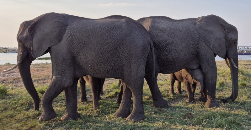
On the way we saw a small group of elephants along the roadside of the A35.
From the turnoff to Tsodilo Hills, we took about an hour on a reasonably good gravel / sand road to reach the main entrance. Please note that a 4×4 is required and that road conditions will vary according to season.

We arrived at 09:00 but the lady who we needed to pay the entrance fee was not yet on duty. (We paid afterwards.) A guide approached us, hopped into our car and we drove to the museum area, a further +- 10 minutes. (If you go later in the day, the guides may already be at the museum area.) He recommended the Rhino Trail around Female Hill, which takes about 2 – 2.5 hours. Our guide was excellent, and we thought it was a most worthwhile excursion.

Okavango Panhandle Mokoro Trip
I asked a tour group that was staying at our camp about the mokoro trip they went on today. They all spoke highly of it and said they had seen crocodiles and elephants and many birds. From the camp, you are taken by boat to the mokoro station. In the panhandle, mokoro trips are offered all year round.
Overnight:
Sepopa area
Day 6: Divundu area – Namibia
We drove in a north-westerly direction further up the panhandle to the Namibian border. At Mohembo, the last village before the border, we visited the Okavango River Bridge.

The attractive Okavango River Bridge, aka the Mohembo Bridge, was opened in 2022 and replaces the Mohembo Ferry. We drove across the bridge and parked in a pull off zone. We then walked back some of the way, enjoying impromptu bird spotting in the flood plain below. The Okavango River is much wider at this point than further south.
The Okavango River (Botswana) is known as the Kavango in Namibia and the Cubango in Angola (where it originates).
The border posts were fairly quiet. Once you cross into Namibia, the road (C48) is a wide gravel road in good condition. The first +-12 km as you travel to Divundu is in the Mahango Core Area of the Bwabatwa National Park. If you are simply transiting, you sign in at the park reception but don’t need to pay an entrance fee.

We didn’t go directly to our lodge as we wanted to visit Popa Falls. The falls are actually rapids and not a particularly special attraction, but I thought we should visit as we were in the area. You visit the falls by going to Popa Falls Resort. After paying an entrance fee at reception, it is about a 5-minute walk to the viewing area. We had lunch at the restaurant which had a pleasant outlook. (Note that there may be a better view of Popa Falls from a lodge across the river.)
After popping into Divundu for a few supplies, we drove back south to our lodge on the Kavango River.

Our lodge had views across the Kavango River to the Buffalo Core Section of Bwabatwa National Park. From our deck we could watch the wildlife across the river. A large herd of elephants came down to drink and wallow at a waterhole. Skittish sables had a quick drink and left. It was difficult to pull myself away for our late afternoon cruise.

The cruise was great: we saw crocodile, hippo, elephant, antelope and many bird species. Near the end, we were directed by the lodge to a spot where two young male lions had returned to snack on a very smelly buffalo carcass.
Overnight:
West bank of the Kavango River
Day 7: Divundu area – Namibia
This morning, we set off early for a self-drive in Mahango Core Section of Bwabatwa National Park. We did the river loop with all the side loops next to the floodplain. The lodge had confirmed that with current conditions, the road should be fine for our car.

We did not see any other vehicles and had a lovely visit marked by the peaceful atmosphere. We saw herds of impala, kudu, lechwe and buffalo, mainly at a distance but some close by. Some of the hippos in a nearby pool still looked fast asleep!
The many bird species on the floodplain ensured we put our binoculars to good use.

Closer to the main road, we saw a small group of elephants as well as giraffe and zebra.
We went to the park reception to pay the entry fee retrospectively and headed back to our lodge for a late breakfast.

For the rest of the day, we relaxed and watched the wildlife across the river from our deck. There were hippos grazing, waterbuck, warthogs, roan antelope, and impala. I was expecting a large herd of elephants at the waterhole again, but a smaller number arrived. Later, we had the wonderful sight of a large herd of buffalo streaming down to the riverbank. It seemed appropriate to see them in the Buffalo Core Section of the Park.
Fellow guests who went on a game drive to the Buffalo Core Section that afternoon, had a great sighting of the lions we had seen the previous day. The lodges take guests across the river by boat to a point where safari vehicles are waiting. This saves the drive to Divundu and across the bridge.

Hippos surfaced in the river in front of our deck with much snorting and grunting.
That night we could hear lions calling in the distance.
Overnight:
West bank of the Kavango River
Day 8: Kongola area – Namibia
The tar road to Kongola, the B8, runs east-west through the Bwabatwa National Park. We drove in game-spotting mode but only noticed one vulture 😉
The river of focus is now the Kwando River. It forms part of the Cuando-Linyanti-Chobe river system (starting as the Cuando in Angola).
The following national parks are in the area:
- Kwando Core Area of Bwabatwa National Park
- Mudumu National Park
- Nkasa Rupara National Park
I made a mistake only allocating one night in this region – there is a lot on offer.
The lodges / camps on the eastern side of the Kwando lead off from the tarred C49. The west bank of the Kwando is less accessible (4×4 only) and is known for deep sand.

We were celebrating a special occasion, so stayed in a beautiful lodge in the Kwando Core Area.


That afternoon we went on a wonderful game drive, the highlight of which was watching a large herd of elephants at Horseshoe Bend. After spending time there our guide continued further south, and we encountered many more elephants in the bush.

We returned to Horseshoe Bend for sundowners where a smaller herd of elephants was now at the water. Not far off was a well-behaved troop of baboons.
Overnight:
West bank of the Kwando River
Day 9: Ngoma area – Namibia

On our way out of the Kwando Core Area, we stopped at the view sites overlooking the flood plain. At the second stop there was a large herd of buffalo heading to water.
Once we were back on the tar road, we parked just before the Kwando River bridge to have a last look out over the Kwando floodplain.
We drove the continuation of the B8 to Katima Mulilo and enjoyed a tea break at a hotel overlooking the Zambezi River.

For lunches, we generally bought bread rolls or bread from supermarkets in the larger towns and made ourselves sandwiches. These were sometimes substituted for fresh chelsea buns, or similar, as available.
We arrived at our next lodge, on the north bank of the Chobe River, in the early afternoon.

There were no trees to shade the tented suites, but the rooms were air-conditioned. Our patio overlooked a mini “vlei” (wetland) – our personal birdwatching spot.
Upon enquiring about booking a game drive, we were told that the lodge only runs game drives (on the Namibian side) when the floodplain is dry enough.
The main deck of the lodge overlooks the Chobe River and floodplain, and you are therefore effectively across the river from Botswana and Chobe National Park. Once in a while, you can see game-drive vehicles across the floodplain in the national park. That afternoon we saw giraffe on the hillside and hippo and herds of impala and zebra on the floodplain.
Overnight:
North bank of the Chobe River
Day 10: Ngoma area – Namibia
We set off on a most enjoyable afternoon cruise at 15:00. The water levels were very low in places, and I doubt if the dry season cruises would continue much longer.

I think we saw the most bird species in this area.
On the floodplain we saw impala, zebra, waterbuck, baboon, warthog and a lone jackal. In the distance, some elephants and buffalo came down the hill to a waterhole.

The morning cruise had a good leopard sighting on the Chobe National Park riverbank. As our boat neared, we knew it was still there as there were two game-viewing vehicles blocking our view. Just as we arrived, the leopard decided to move to a spot where no one could see it anymore. I therefore saw it through my binoculars for a few seconds 😉
That night I was woken by a loud banging sound. Other guests shone their spotlights into the darkness illuminating two elephants about 100 m away. Villagers must have been chasing the elephants away from their homes.
Overnight:
North bank of the Chobe River
Day 11: Kasane – Botswana
After a leisurely start, we headed to the border at Ngoma. A tour group sneaked in ahead of us, slowing us down on the Botswana side. For a distraction, there is a hollow baobab tree if you want to take a pic. We underwent the shoe and tyre disinfection process, and an official checked our car for restricted goods.
The A33 is a tar road that crosses Chobe National Park between Ngoma and Kasane. If you are transiting, you sign in at the park office but don’t need to pay an entrance fee. We saw several small groups of elephants along the road as well as a few solitary steenbok.

We continued past Kasane to Kazungula to look at the bridge that spans the Zambezi River. The bridge was opened in 2021 and connects Botswana and Zambia. It is surprising to think that all traffic previously used to make use of the Kazungula Ferry.
Visiting the Kazungula Bridge and quadripoint-zone

In order to visit the Kazungula Bridge, turn onto the minor road at the Trans Cash & Carry and park near the gate of the old border post. Then walk up to, and along, the bridge, which has a wide pedestrian walkway.
Do not proceed on the A33 towards the bridge in your vehicle beyond this point as you will somehow leave Botswana without being aware of it and have to return through Botswana border processing. (We speak from experience 😉)
Besides the view, you will be at the spot where two international tripoints are separated by a short distance (Namibia-Botswana-Zambia tripoint and Zambia-Zimbabwe-Botswana tripoint). There is unfortunately not an international quadripoint, but rather an “almost-quadripoint” or a “quadripoint-zone”.
Overnight:
Kasane. There are many accommodation options in Kasane.
Day 12: Kasane – Botswana
Our game-drive vehicle picked us up and we arrived at the Chobe National Park entrance at opening time. There were many other vehicles, all jostling for position. Our guide seemed a bit laidback, but I soon discovered why – once the gates opened, the vehicles magically dissipated.

We travelled primarily along the “main” road (River Route), and loops to the floodplain. We saw a lot of game including roan antelope. A passing vehicle tipped us off about a lion sighting further west. Four lionesses were eyeing a herd of tightly packed buffalo. After watching them for a while, we reluctantly left as we had only booked a morning game drive.
As we drove back, we came upon several vehicles at a leopard sighting. We could see the leopard well-camouflaged under a bush. The leopard moved into an open gap and seemed to be interested in nearby impala. We unfortunately couldn’t stay all day, so we headed back to our accommodation where they were kind enough to serve us a late breakfast.
If we were to do this again, we would rather do a half-day or full-day game drive.

That afternoon we went on a sunset cruise. The boats circumnavigate Sedudu Island in the Chobe River. Once again, we were treated to good wildlife sightings. It was special to be able to get so close to some of the animals.
Overnight:
Kasane
Day 13: Kasane – Botswana

This morning, we went on another Chobe early morning game drive. The first part of the drive was along the Upper Route.
It was appropriate to see two kori bustards, the national bird of Botswana.
Today there was time to break the drive with a stop for tea / coffee and rusks.

We moved to a lodge that made the most of its river frontage and relaxed that afternoon.
If you haven’t been to Victoria Falls before, then you may wish to take advantage of a day trip across the border to Zimbabwe.
Also, almost every location we went to offered cultural (village) tours specific to that area.
Overnight:
Kasane
Day 14: Nata area – Botswana
Mid-morning we left on the A33, travelling south to the Nata area. As usual, you need to be on the lookout for domestic and wild animals.
Near Pandamatenga, there was a change in scenery because of extensive crop farming.
There were several sections of road before and after Nata undergoing roadworks.
Our accommodation today was a safari tent. This lodge, as was the case with almost all the lodges / camps, had a pool to cool down in.

The reason to stay overnight in the Nata area, is to visit the Nata Bird Sanctuary. The sanctuary is on the north-eastern edge of the Sowa / Sua Pan, one of the Makgadikgadi pans.

Conditions in the pans vary dramatically based on season and rainfall.

I am not sure why the tours only left at 16:30 but there was enough to look at that we ended up rushing to reach the water in time for sunset. There was a large flock of pelicans on a far bank, but the light was already too low for good viewing.
Overnight:
Nata area
Day 15: Lephalale – South Africa
Our wonderful holiday was over and all that remained was the long drive back home, which we broke in Lephalale.
References:
- https://whc.unesco.org/en/list/1021 – retrieved Oct 2025
You may also like:
Central Namibia road trip itinerary 6 days