Last Updated on: 18th December 2025, 02:39 pm
Golden Gate Highlands National Park is in the north-eastern Free State Province of South Africa, just north of Lesotho.
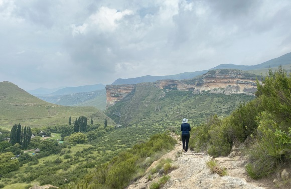
The main focus of Golden Gate is the sandstone formations, including outcrops, cliffs, and caves, with their varied hues of ochre. There is a public road, the R712, that runs through the park. You can see many of the weathered sandstone formations from the road, but it is even better to get up close on a hike.
In order to hike or to do the drives, get your permit by paying the Daily Conservation Fee at the Glen Reenen Information Office.
Fees are as follows: https://www.sanparks.org/parks/golden_gate/tourism/tariffs.php
There is an abandoned toll gate on the road from Clarens to Glen Reenen Camp.
If you are not a trail runner you may wish to avoid the park at the time of the annual Golden Gate Challenge race (month varies).
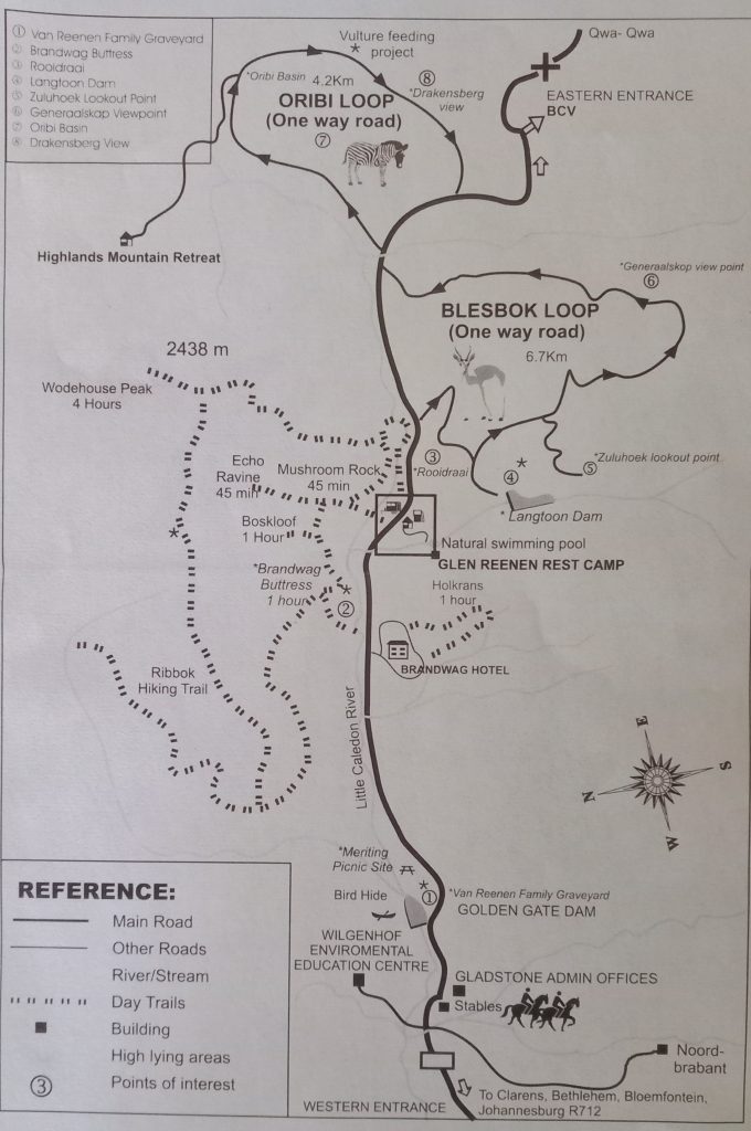
Golden Gate Highlands National Park self-drive routes
From a wildlife perspective, you won’t see the “big five” at Golden Gate, but there are 10 species of antelope in the park: eland, red hartebeest, black wildebeest, blesbok, springbok, mountain reedbuck, grey rhebok, common / grey duiker, steenbok and oribi.
There are two short tarred self-drives routes:
- Blesbok Loop (6.7 km): A lovely drive that takes you into nature.
- Oribi Loop (4.2 km): On a clear day there are great views of the northern Drakensberg in the distance to the south. You can also stop at the Vulture Feeding Project and hopefully see bearded vultures (lammergeiers) and Cape vultures. The feeding takes place on an unscheduled basis.
Dinosaur Interpretive Centre

Golden Gate Highlands National Park is a palaeontologist’s paradise. Many dinosaur fossils have been found here including nests of eggs with some of the world’s oldest fossilized dinosaur embryos.
The Kgodumodumo Dinosaur Interpretive Centre has special brickwork that represents dinosaur scales, and the building has been designed to blend in with the landscape.
Half-day hikes in Golden Gate Highlands National Park
Please see the official SANParks Golden Gate Hiking Trail Guide.
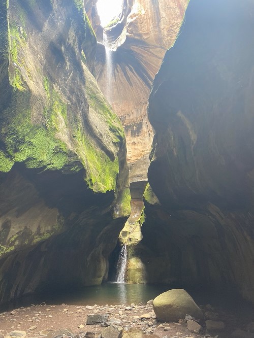
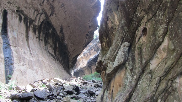
Cathedral Cave Trail
This trail is a guided trail that must be booked in advance (SANParks is now recommending three days in advance) and requires a minimum of five participants. The fee for 2025 / 2026 is R223 per person.
The southern bald ibis breeds at the cave and the trail is closed during the breeding season. Another factor that is considered when deciding the opening date, is the arrival of the first good spring rains.
The SANParks gghnp-activities.pdf document states that the trail is open from December to October – this is incorrect. Our guide said that the Cathedral Cave trail is closed July, August and September each year, however when I followed up with the Information Centre, they gave different timeframes.
In 2023, the trail was closed from May to August.
In 2024, the trail was closed from May to sometime in October.
In 2025, the trail was closed from May. When I called on 07 October, they confirmed that the trail has already been reopened.
This is an easy walk: we started near the stables, and it is a 3 km walk outbound with an elevation gain of about 100 m and a 3 km return.

The roof of the cave has partially eroded. A waterfall falls into an upper pool with a smaller waterfall into the lower pool. You can swim across the lower pool to a chain ladder to climb up to the upper pool. The people who went ahead of me said getting to the upper pool was very slippery, so I decided not to take the risk.

If you prefer to stay dry, there are wooden ladders which take you high up to a bridge from where you can view the upper pool. As at Dec 2025, these ladders are still broken and unsafe to use.
Mushroom Rock Trail, Echo Ravine Trail, Boskloof Trail, Brandwag Buttress Trail

These are all short trails which have a common starting point across the road from the Glen Reenen Information Centre. Cross the little bridge and follow the signs.
Our gps recordings for these trails indicate elevation gains of about 20% less than those shown on the AllTrails maps. Subjectively, the elevation gains also felt less. It is however difficult to be sure of the actual values owing to the cliffs obstructing gps signals and the maps not accurately reflecting the terrain.
Mushroom Rock Trail

This trail can be done as a loop, but the disadvantage is that the last section is along the road.
Distance: +- 2.2 km
Cumulative elevation gain: +-100 m
If you would like to view an interactive map of this trail, please go to: Map of Mushroom Rock Trail in Golden Gate Highlands National Park. (The AllTrails app is needed if viewing the map on your phone.)
Echo Ravine Trail
Out-and-back trail.
Distance: +- 2 km
Cumulative elevation gain: +- 160 m
If you would like to view an interactive map of this trail, please go to: Map of Echo Ravine Trail in Golden Gate Highlands National Park. (The AllTrails app is needed if viewing the map on your phone.)
Boskloof Trail
Boskloof was a bit underwhelming for me.
Out-and-back trail.
Distance: +- 2 km
Cumulative elevation gain: +- 130 m
If you would like to view an interactive map of this trail, please go to: Map of Boskloof Trail in Golden Gate Highlands National Park. (The AllTrails app is needed if viewing the map on your phone.)
Brandwag Buttress Trail

This trail can be done as a loop, but the disadvantage is that the last section is along the road.
Distance: +- 3 km
Cumulative elevation gain: +- 190 m
If you would like to view an interactive map of this trail, please go to: Map of Brandwag Buttress Trail in Golden Gate Highlands National Park. (The AllTrails app is needed if viewing the map on your phone.)
Golden-combo Loop

We combined all the above trails into one hike.
Distance: +- 5 km
Cumulative elevation gain: +- 390 m
If you would like to view an interactive map of this trail, please go to: Map of Golden-combo Trail in Golden Gate Highlands National Park. (The AllTrails app is needed if viewing the map on your phone.)
Holkrans Trail

The Holkrans Trail is a loop that starts behind the Golden Gate Hotel. The trail visits the Holkrans Kraal and two caves. You need to be comfortable with climbing wooden ladders, as there are several.


Distance: 2.4 km
Cumulative elevation gain: +- 130 m
If you would like to view an interactive map of this trail, please go to: Map of Holkrans Trail in Golden Gate Highlands National Park. (The AllTrails app is needed if viewing the map on your phone.)
Wodehouse Peak Trail

The Wodehouse Trail is a loop that includes Brandwag Buttress before later heading up the mountain above, reaching a maximum elevation of about 2400 m.

At the top we saw black wildebeest fairly close, and blesbok in the distance. There are lovely views on the way up and from the top. To the south-east you can see the northern Drakensberg. On the way back, the trail visits Mushroom Rock.
Please note that since 2024, the descent has changed and the trail is now a little longer than before.

Distance: 10.5 km (including walking to the edge of Brandwag Buttress)
Cumulative elevation gain: 710 m
If you would like to view an interactive map of this trail, please go to: Map of Wodehouse Peak Trail in Golden Gate Highlands National Park. (The AllTrails app is needed if viewing the map on your phone.)
Where to stay?

There are several accommodation options: Glen Reenen Rest Camp (1920 m), Golden Gate Hotel and Chalets, Noord-Brabant Farmhouse, and Highlands Mountain Retreat (2230 m). There is a natural rock pool in the hills behind Glen Reenen where you can swim.
As at February 2025, accommodation is not available at the Basotho Cultural Village.
Nearby, Clarens has plenty of accommodation too.
Basotho Cultural Village

If travelling towards Harrismith from Glen Reenen Rest Camp, the turn-off to the village is to the right about 20 km from Glen Reenen.

The village is a “living museum”, with actors representing various roles. There are opportunities for tourists to participate, including tasting sorghum beer. Standard tours are about 40 minutes long and do not need to be booked. Our guide was very knowledgeable and I thought the tour was interesting and well presented.
Clarens

Clarens is a quaint village centred around its square. There are many art galleries, speciality shops, and eateries. Clarens is in a picturesque setting with mountain views and has its own nature reserve with some walking trails.
Glen Reenen Rest Camp / Office is a 23 km drive from Clarens.
Ash River Outfall
The Ash River Outfall is about 10 km north of Clarens.
The outfall is at the end of a 37 km tunnel from a reservoir which is part of the Lesotho Highlands Water Project. From here the water eventually flows into the Vaal Dam.
You can also see a cross-section of the huge concrete tunnel pipe.
You may also like:
Northern Drakensberg Hikes and Area Guide
Monks Cowl Reserve in the Drakensberg
Encountering baboons in the wild
4 replies on “Golden Gate Highlands National Park Hikes and Area Guide”
Phenomenal detail
Thanks Chantal
❤️
Thank you Maria👍
Love all the places.
Nwabisa, so do I 🙂