Last Updated on: 22nd May 2025, 04:50 pm
The Cederberg lies in the Western Cape, a few hours’ drive north of Cape Town.
The Cederberg Complex includes the Cederberg Wilderness Area, Matjiesrivier Nature Reserve and Hexberg Nature Reserve, and is managed by CapeNature. This CapeNature document provides a good overview addressing climate, fauna, flora, rock art, and more: https://www.capenature.co.za/uploads/files/CapeNature-Cederberg-2025.pdf
My post only covers day hikes in the southern Cederberg area.
I had always assumed that you had to embark on a multi-day hike, carrying tents and water, to see iconic Cederberg landmarks such as the Maltese Cross, Wolfberg Arch and Lot’s Wife. When a friend told me about the day hikes, we set about planning a trip! We visited the Cederberg in the first half of May.
Besides Cape Nature accommodation, there is also private accommodation available. We based ourselves at Sanddrif, which was conveniently located for the hikes we were doing.
Please note that you need permits for most of these trails and walks.
Lot’s Wife and Window Rocks Trail

This trail is a loop. The trail starts from the parking area next to the road to Algeria, about a kilometre or two from Sanddrif Reception. We went anti-clockwise, which worked well as the first half of the trail has more unusual rock formations than the second half. I was surprised to learn that Lot’s Wife can be seen from the road.


Our measurements:
Distance: 4.2 km
Cumulative elevation gain: +- 125 m

Maltese Cross Trail

This out-and-back trail starts from the parking area about 7 km from the Sanddrif Reception. After the main ascent, the Maltese Cross and Sneeuberg come into view. Sneeuberg, at 2027 m is the highest peak in the area.


You can walk around the Cross for different perspectives of the rock formation.
Our measurements:
Distance: 7.3 km
Cumulative elevation gain: +- 460 m

Wolfberg Cracks Trail

Many hikers may assume that the Wolfberg Cracks is simply a route to be negotiated on the way to the Wolfberg Arch. The Wolfberg Cracks are however wonderful and are worthy of a visit in their own right.
This out-and-back trail starts from the parking area over a kilometre from the Sanddrif Campsite.
We combined the Cracks and Arch, so we set off early. The ascent to the start of the Wolfberg Cracks has an elevation gain of +- 500 m. Once you near the base of the Cracks, it is no longer so obvious where to head. A few prominent signs would be helpful for first-timers.

Looking upwards, the Wide Crack is to the left of the Narrow Crack. The Wide Crack is much easier than the Narrow Crack. If you want to experience both Cracks, it is generally advised to go up the Narrow Crack and come back via the Wide Crack.
Once you are out of the Narrow Crack area at the top, turn left and you will find the Wide Crack route down. Please see the description below that describes navigating the Cracks.
Standard measurement from AllTrails: (Our measurements were impacted by the gps going wild in the Cracks, so I have used standard measurements.)
Distance: 4.2 km
Cumulative elevation gain: 550 m
Pictorial guide to navigating up the Narrow Crack
The Narrow Crack has some sections that are tricky if you are not a rock climber or mountain goat. This guide aims to give you an indication of what to expect.

At the start of the Narrow Crack route, there are two options:
1) A climb up the rock pictured above. There is a wooden foothold and two handholds that have been bolted into the rock. A few members of our group (including myself) needed some pushing assistance to get up 😉
2) There is a route through a hole behind the huge rock blocking the way. We did not investigate this option, but I have read that it involves a dark area and some scrambling and squeezing before reaching the ledge.
You then walk around a narrow ledge, which has a rope rail to provide some reassurance.

Soon after the ledge, there is another rock to get up. This one is much easier than the first one.

Make your way across the rocks to the area I have marked in pink. There is an arrow scratched on the rock at that point.

There are several narrow passages on the Narrow Crack route. I had to take off my daypack and move sideways through the narrowest one.
Remember to bring a headlamp as some of the areas are dark.

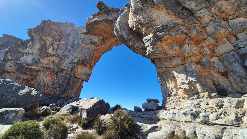
The route opens up again to an area with a beautiful arch.


Some of our group appreciated a leg-up for the last rock climb. Others preferred to do a chimney manoeuvre.

The final challenge requires hikers to get through a small space under a chockstone. The technique is to get on your back, go headfirst, and push with your legs. There is sand (like river sand) on the floor. While the space is quite narrow, it is not long. I do not like enclosed spaces but had no difficulty with this. You have to be careful not to bump your head as you sit up out of the crawl-space. There is a way to climb over this section if you can’t wriggle through.
We were a group of 5 and it took us about an hour and a half to get from the start to the end of the Narrow Crack route.
Pictorial guide to navigating down the Wide Crack


After starting easily, we were confronted with very large rocks. There was much scrambling down these rocks.

Apparently, you need to stick to the left side of the Wide Crack when it starts widening. Once again, a prominent sign would have been helpful. The left route is the easiest and is described as a walk with some scrambling. I don’t know which way we came down but I lost my sense of humour when I had to perform acrobatics to get down rock after rock. That being said, it was fairly quick to come down the Wide Crack.
Wolfberg Cracks and Arch Trail

This out-and-back trail starts from the parking area over a kilometre from the Sanddrif Campsite.
We set off early to ensure we had shade on the way up. The ascent to the start of the Wolfberg Cracks has an elevation gain of +- 500 m. Once you near the base of the Cracks, it is no longer so obvious where to head.
Please see the Wolfberg Cracks Trail description above for information about finding your way to and through the Cracks.
After we exited the Narrow Crack, we had a snack break and then set off on the +- 4 km walk to the Wolfberg Arch. You need to follow the cairns and if that fails, look out for footprints in the sand.

After a while, you can see the Arch in the distance. Nearing the Arch, there is a gentle ascent of +- 100 m to get to the Arch.


You return the same way.
If you do not want to go through the Cracks to get to the Wolfberg Arch, there are alternative routes that can be considered.
Standard measurement from AllTrails: (Our measurements were impacted by the gps going wild in the Cracks, so I have used standard measurements.)
Distance: 11.6 km
Cumulative elevation gain: 798 m

You may also like:
Drakensberg day hikes from Monks Cowl
Northern Drakensberg hikes and area guide
6 replies on “Cederberg day hikes”
My wife and I are planning an overnight expedition to the Wolfberg Arch early Friday, 1 May 2026. We are looking for 1 or 2 reliable hikers to join us so we can meet the CapeNature “Rule of Three” for the permit. Will be great if there is some groups going on the 1st of may and we can just join in.
The Mission:
Route: Ascent via Big Cracks.
Goal: Camping at the Arch for sunset, sunrise
Pace: Steady and focused. I will be carrying a heavy load, so we aren’t rushing, but we are committed to the summit.
The Ideal Partner:
Has their own overnight gear and is self-sufficient.
Is fit enough for the vertical scramble of the Cracks.
Reliable and safe-minded. Will be great to know if there are any groups going the same day
Hi Jacques, I suggest that you put a post on the Facebook group: “Hikers – South Africa”. I hope you find hikers to accompany you.
I am interested in hiking the Sederberge.
I am sure you will enjoy the Cederberg 🙂
Hi, did you camp or was it self catering accommodation and if so, what is name of place please? I would like to do day hikes but not camp!
Hi Colleen
We stayed at Sanddrif Holiday Resort – they have self-catering cottages as well as campsites. There are also other options in the area.