Last Updated on: 6th November 2025, 03:32 pm
Where is Monks Cowl Reserve?
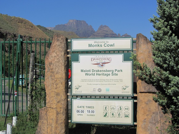
Monks Cowl Reserve is in the central Drakensberg in KwaZulu-Natal and forms part of the Maloti-Drakensberg Park World Heritage Site. It was previously known as Monk’s Cowl Forest Station. (The apostrophe seems to have been dropped in the official naming).
In Google Maps, the location is indicated as Monks Cowl Campsite and Caravan Park. It is managed by Ezemvelo KZN Wildlife: http://www.kznwildlife.com
The R600 road from Winterton through the Champagne Valley terminates at the gate of the reserve. The area nearer to Winterton is mainly agricultural and becomes more tourist-oriented closer to the mountains with hotels, time-share resorts and other accommodation options. The Champagne Valley (Cathkin Park) is the most developed of the access areas to the KZN Drakensberg: there are several shops, eateries and adventure and sports activities available. These amenities are generally spread out and do not overwhelm the natural character of the area. The valley is also home to the Drakensberg Boys’ Choir who hold concerts during term time.
Why visit Monks Cowl?
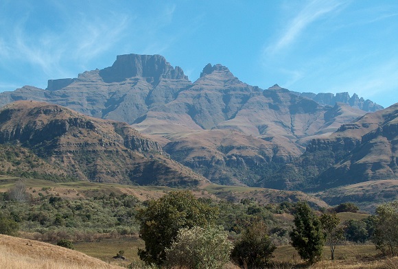
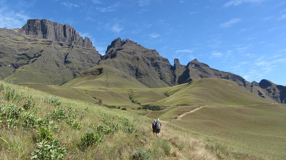
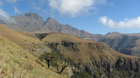
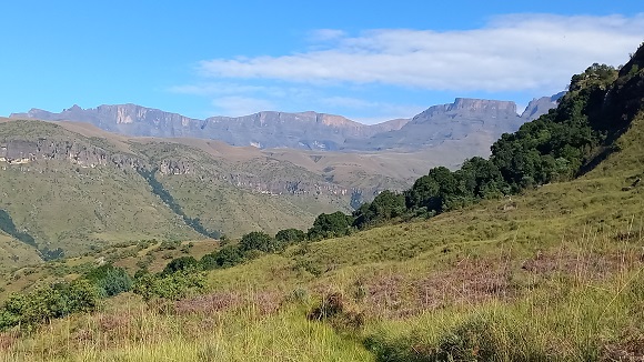
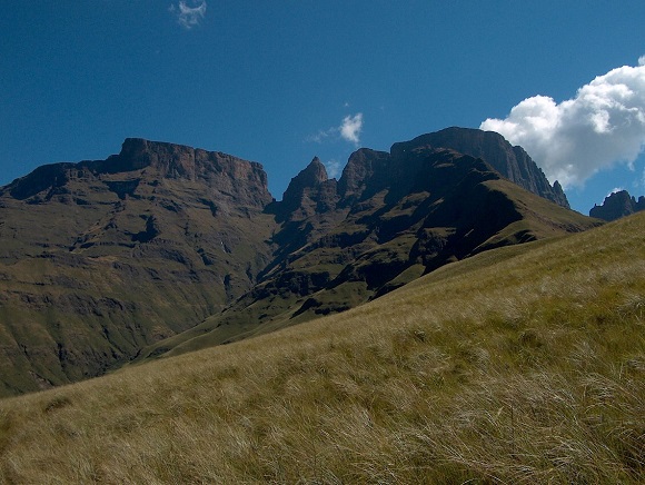
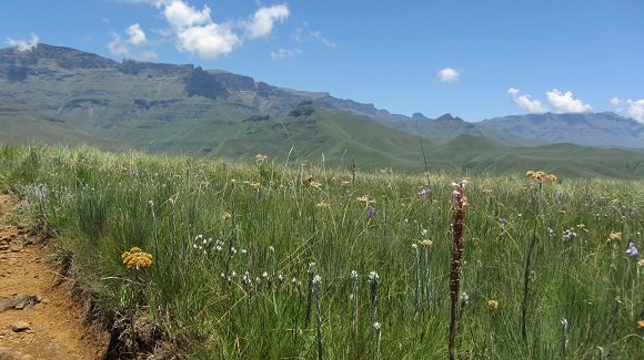
Monks Cowl Reserve is the main access point for hikers to this part of the High Berg, Little Berg and Contour Path. Even if you are not interested in hiking, the spectacular views of the magnificent mountains are more than enough reason to visit.
The mountains here are amongst the highest in the Drakensberg range[1] and therefore in southern Africa:
- Champagne Castle – 3,377 m (11,079 ft)
- Monk’s Cowl – 3,229 m (10,594 ft)
- Cathkin Peak – 3,148 m (10,328 ft)
- Sterkhorn (Mount Memory) – 2,973 m (9,754 ft)
In his classic book, Barrier of Spears, Reg Pearse records that Champagne Castle and Cathkin Peak were named as such by a Major Grantham who came to Natal to conduct a military survey in 1861.
According to Pearse: “The Zulu name for Cathkin is Mdedelelo, meaning ‘make room for him’. It is usually applied to a bully who pushes everyone else out of the way.”
Pearse goes on to say: “Champagne Castle is actually a rounded dome set a few hundred metres inland from the edge of the escarpment, but the precipitous cliffs of the escarpment on two sides of the mountain are usually considered part of Champagne Castle.”
Strangely, Monk’s Cowl peak cannot be seen from its namesake. Monk’s Cowl is between Champagne Castle and Cathkin Peak and only visible from certain points.
Half-day hikes from Monks Cowl Reserve
There is a large parking area for day visitors. For all walks and hikes, first check-in at the office, fill in the register and pay the daily conservation fee.
The Monks Cowl conservation / entrance fee for day hikers (2025/2026):
For RSA citizens / residents and SADC nationals: R80 per adult, R40 per child. [2]
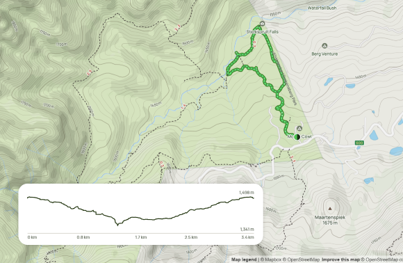
The office usually has a maps available.

You will note that some of the distances on the map above do not match the distances documented in this post.
Sterkspruit Falls Trail (3 km)
This is the easiest walk in Monks Cowl Reserve.
Refer to the map above.
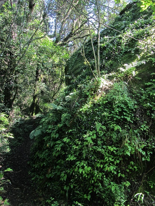
Walk a few metres beyond the office and then turn right. Follow the signs to Sterkspruit Falls. You walk in a forested area for about 10 minutes.
Take the right fork where the path splits. There are views of the beautiful High Berg as you walk. The path leads downwards to the Falls viewpoint, where there is a fence.
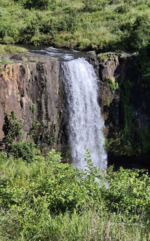
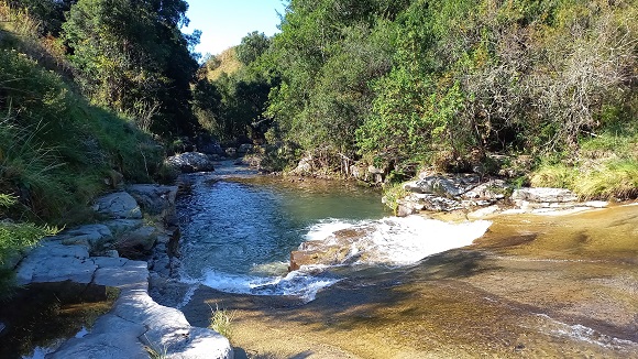
After the viewpoint, the path is parallel to the river. You can take a short detour down to the pools. It is not clear to me if there is a convenient place to get in and out of the pools if you want to swim.
This route is a semi-loop and is about 3.4 km long with a cumulative elevation gain of +- 130 m.
We took about 1 hour 10 minutes to walk the trail, including a stop at the Sterkspruit Falls viewpoint and a short stop at the pools.
Nandi’s Falls Trail (7 km)
Refer to the map above.
Walk a few metres beyond the office and then turn right. Follow signs to Pools and Nandi’s Falls.
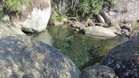
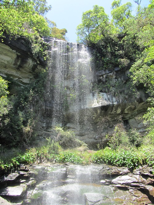
The path heads down towards the Mpofane (Sterkspruit) River. When close to the river, the path branches off to the first set of pools. After visiting the pools, return to the main path which follows the course of the river upstream. The path branches off to another set of pools and also to a river view spot along the way. Nandi’s Falls is in a lovely cool treed setting. You can walk behind the waterfall. On the way back, follow the signs to the office.
This is a circular route and is about 7.2 km long with a cumulative elevation gain of +- 296 m.
We took just over 3 hours to walk the trail. We walked at slow pace and stopped at the pools along the way. The time includes a +- 20-minute stop at the falls.
If you would like to view an interactive map of this trail, please go to: Map of Nandi’s Falls Trail in the Drakensberg from Monks Cowl Reserve. (The AllTrails app is needed if viewing the map on your phone.)
Hlatikhulu Forest Trail (8 km)
Refer to the map above.
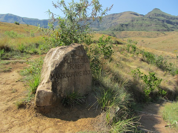
Walk a few metres beyond the office and then turn right. Follow signs to Pools and Hlatikhulu Forest. Branch off down to the river at the sign with the marking “Hlatikhulu Forest” and “Makhulumane Rock”.
Cross the Sterkspruit (Mpofane) River. In winter it is easy to rock-hop. In summer we take our shoes and socks off and wade across.
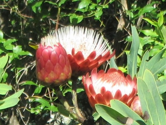
The path then heads upwards for a gain in elevation of 130 m to the Hlatikhulu Forest – Makhulumane Rock junction, plus 30 m immediately thereafter (130 m + 30 m = 160 m). The trail passes through beautiful indigenous forests and open grasslands dotted with proteas. There are several streams in the forests and rocks may be slippery in summer. At the end of the part of the trail north of the river, the river is crossed in the reverse direction. Follow the signs to return to the office.
This is a circular route and is about 8 km long with a cumulative elevation gain of +- 300 m.
We took less than 4 hours to walk the trail at a slow pace.
If you would like to view an interactive map of this trail, please go to: Map of Hlatikhulu Forest Trail in the Drakensberg from Monks Cowl Reserve. (The AllTrails app is needed if viewing the map on your phone.)
Makhulumane Rock Trail (9 km)
Refer to the map above.
Follow the same route as the Hlatikhulu Forest Trail to the Hlatikhulu Forest – Makhulumane Rock junction on the north side of the river. You will have gained 130 m in elevation to the junction, plus 30 m immediately thereafter (130 m + 30 m = 160 m).
The path is then fairly level for a further 2 km to the Makhulumane Rock – Drakensberg Sun junction. There are patches where bracken and brambles encroach on the path (sometimes to chest height). I recommend taking a stick for bushwhacking purposes. This is probably more of a problem in summer than in winter.
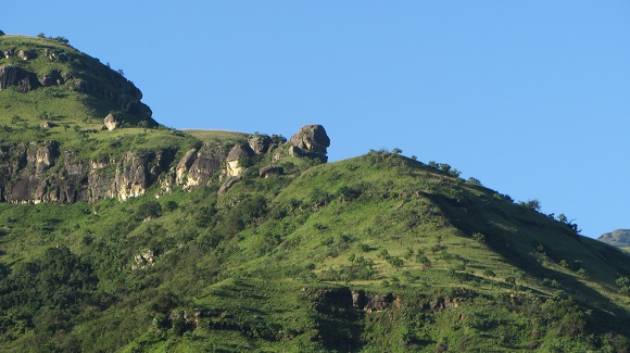
The junction is shortly after you climb over the stile. At the junction, take the left fork and Makhulumane Rock is on the right-hand side of the trail as you enter the forest. This is the end of the hike and you return via the same route. The trail (out-and-back) is about 9.1 km long with a cumulative elevation gain of +- 323 m.
We took less than 4 hours to walk the trail at a slow pace.
If you would like to view an interactive map of this trail, please go to: Map of Makhulumane Rock Trail in the Drakensberg from Monks Cowl Reserve. (The AllTrails app is needed if viewing the map on your phone.)
Optional extra: After Makhulumane Rock, you can continue further into the very beautiful forested kloof up a steep path. This is known as the Makhulumane Forest / Kloof / Valley trail. I saw two little waterfalls with a pool each that looked as though they could be a good place to take a dip on a hot day. There was also a taller waterfall near the upper end of the forest. The path eventually exits the forest and continues up the grassland slope to the top of the Little Berg. For more information, please see the Makhulumane Forest – Hlatikhulu Nek Loop day hike description below.
The Sphinx Trail (5 km)
Refer to the map above.
Walk about 100 m beyond the office and then turn left onto the path at the sign. The path progresses steadily upward, first through a forested area and then in the open, eventually levelling out below the cliffs.
Crystal Falls and Pool is lovely spot to stop. From here, the path is fairly level until you go up the side and behind the Sphinx. From the Sphinx area, there are great views of the valley below. Return via the same route.
The trail (out-and-back) is about 4.75 km long with a cumulative elevation gain of +- 312 m.
We took over 2.5 hours to walk this trail at a slow pace. This includes a 10-minute stop at Crystal Falls and a 15-minute stop at the Sphinx.
If you would like to view an interactive map of this trail, please go to: Map of the Sphinx Trail in the Drakensberg from Monks Cowl Reserve. (The AllTrails app is needed if viewing the map on your phone.)
Blind Man’s Corner (11.5 km)
Follow the route as set out in the table below:
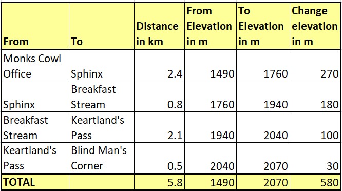
From the Monks Cowl Office, the trail proceeds upwards to the Sphinx and then further upwards to Breakfast Stream.
On the way to Breakfast Stream, Intunja (Gatberg) comes into view in the distance to the north-west. Intunja is interesting because it has a hole through it near the top.
Just before Breakfast Stream, a path branches off to the left. This allows you to take a short steep detour up Verkykerskop, with an increase in elevation of about 40 m.
When you reach Breakfast Stream you will be on top of the Little Berg and the path continues for an easy 2.6 km to the contour path.
Blind Man’s Corner is not really a destination in itself; it is the point where you join the contour path in this area.
We took 3 hours to reach Blind Man’s Corner at a slow pace. (Strong hikers will get here considerably faster). After a 30-minute break, it took us 2.5 hours to return the way we came, for a total of about 6 hours.
An alternative route outbound or back is via Keartland’s Pass. This route is much the same distance but has steeper sections.
If you would like to view an interactive map of this trail, please go to: Map of the trail to Blind Man’s Corner in the Drakensberg from Monks Cowl Reserve. (The AllTrails app is needed if viewing the map on your phone.)
Carter Trail to Wonder Valley (10.2 km + 2.2 km + 2.2 km)
The Carter Trail is a new hiking trail which was cut after 2020.
A potential inconvenience of this trail is that it does not start from Monks Cowl Reserve.
The trail can be accessed from the Champagne Castle Hotel but when I called to confirm day-hiker access, it was categorically stated that the Hotel does not allow non-residents to hike from the property.
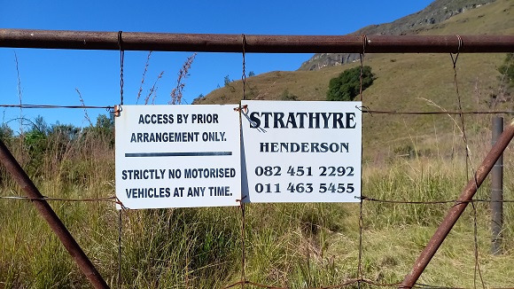
The other way to get to the trail is to sign in at the Monks Cowl Office, then walk +- 2.2 km along the road (a pleasant walk) to the Strathyre gate pictured above. Please contact the property owner and get permission in advance. From the gate, follow the unmaintained path directly up the hill (70 m elevation gain), then through the fence, after which you soon intersect the trail.
The trail skirts the Matterhorn mountain in a south-eastly direction. Once you “round the corner”, you are rewarded with views of Wonder Valley and the High Berg from Old Woman grinding Corn to Sterkhorn.
There is a +- 170 m descent to Spitsberg Stream which is a great spot for a tea break and a swim.
As at mid-2023, the part of the trail that descends to the river still needs to be completed – the wooden logs have not yet been put in place. There were some slippery clay sections when we were there.
This is an out-and-back route and is about 10.2 km long with a cumulative elevation gain of +- 415 m.
If you would like to view an interactive map of this trail, please go to: Map of Carter Trail to Wonder Valley in the Drakensberg. (The AllTrails app is needed if viewing the map on your phone).
Day hikes in the Monks Cowl area
Contour Path
Hike to Blind Man’s Corner as described in the section above and then follow the contour path northwards or southwards as far as you wish. It is easy hiking, so it is useful to remind yourself that for every kilometre walked, you are adding a kilometre to the return hike.
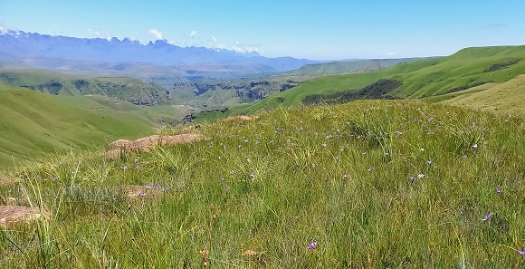
What I love about the contour path is that wonderful new perspectives of the mountains present as you wind your way around the spurs.
If you head northwards, a good milestone is Hlatikhulu Nek, where the path from Steilberg joins the contour path. Hlatikhulu Nek is about 3 km from Blind Man’s Corner, resulting in a hike of about 17.6 km (5.8 + 3 + 3 +5.8).
Makhulumane Forest – Hlatikhulu Nek Loop (20 km)
Follow the route as set out below:
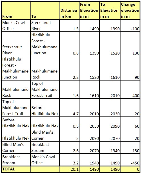
From the Monks Cowl Office, hike to Makhulumane Rock and then continue up the Makhulumane Forest trail. This part of the trail ascends steeply for 400 m. I estimate that just over half of the ascent is in the forested kloof and the rest is on the open grassland slopes.
From the top of the Little Berg, there are views north-eastwards down into the Champagne Valley and also views north-westwards of the Cathedral range.
The 5.2 km contour path to Hlatikhulu Nek is easy to follow but plants encroached on the path in places when we were there. As you get closer to Hlatikhulu Nek, Dragon’s Back comes into view as well as the hole in Intunja / Gatberg.
If you would like to view an interactive map of this trail, please go to: Map of Makhulumane Forest – Hlatikhulu Nek Loop trail in the Drakensberg. (The AllTrails app is needed if viewing the map on your phone.)
The distance of the Makhulumane Forest section of the hike is estimated to be about 1.6 km (as opposed to the 1.1 km on the map). Also, it is difficult to understand the 912 m cumulative elevation gain indicated on the map. As can be seen from the table above, the main elevation gains amount to +- 700 m.
Sterkhorn
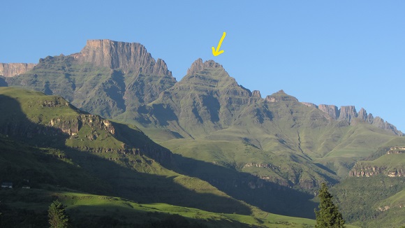
Sterkhorn is also known as Mount Memory as there is a cross on top (a MOTH war memorial).
There are two main peaks: Sterkhorn North (2880 m (estimate from hikers)) and Sterkhorn South (2973 m). It is Sterkhorn North that can be hiked.
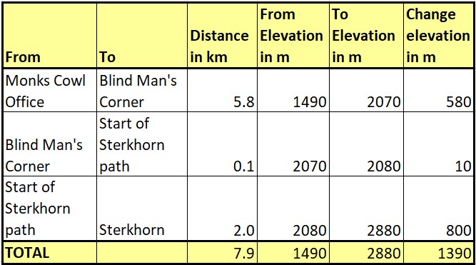
Hike to Blind Man’s Corner and then turn left (southwards) on the contour path. After about 100 – 150 m, take the path to the right just before the trees. Cross the stream and cross the campsite. (Note: when I was there last, this now seems to be the contour path route anyway.) From there, the steep path ascends about 800 m (2880 – 2080) over about 2 km.
I have not hiked Sterkhorn myself as I am not fit enough, so I chatted to hiker friends who provided the following tips:
- There are one or two places that may be a bit challenging for those that do not have a head for heights.
- About midway up, when the cliffs are on your left, there is a section that can be confusing: Along the cliff path, there is a point (there are cairns) where you need to take a path left up the cliff. The other path continues straight on but then dies out.
- Near the top there is a chimney that is about 2 m high.
If you would like to view an interactive map of this trail, please go to: Map of the Sterkhorn trail in the Monks Cowl area. (The AllTrails app is needed if viewing the map on your phone.)
Intunja / Gatberg
Intunja (Gatberg) is a 2408 m mountain to the north-west of Blind Man’s Corner and can be accessed from the contour path. It is special because it has a hole through it near the top. You can hike to the base of the hole.
I have not done this hike and the information below is provided to give an indication of the fitness levels that would be required.
I have read that the best way to ascend Intunja (Gatberg) is from the north-east.
If done as a day hike:
- Distance to base of Intunja from Monk’s Cowl Office: 12.2 km
- Distance up Intunja: +- 1.5 km (?)
- Cumulative elevation gain to base of Intunja: 766 m
- Elevation gain to base of hole: +- 350 m (?)
If done as a day hike, the return trip is therefore about 12.2 + 1.5 + 1.5 + 12.2 = 27.4 km.
If you would like to view an interactive map of this trail, please go to: Map of the trail to the base of Intunja in the Drakensberg from Monks Cowl Reserve. (The AllTrails app is needed if viewing the map on your phone.)
References:
- https://en.wikipedia.org/wiki/List_of_mountains_in_South_Africa -retrieved 202010
- http://www.kznwildlife.com/Tariffs.html
You may also like:
Northern Drakensberg Hikes and Area Guide
Encountering baboons in the wild
Longer hikes in and around Gauteng
4 replies on “Monks Cowl Reserve in the Drakensberg”
Your article on the Monks Cowl Reserve is exceptionally informative – and being so well presented it is most useful to visitors and hikers.
Having such good information to hand makes it easy to plan one’s time in the ‘Berg, and helps to get the most out of the time spent there.
Thank you.
WG – thank you for your kind comment.
Agreed. Thanks very much.
Thank you Robert H